AI for groundworks & geotech engineering.
Measure groundworks and earthworks requirements from PDF drawings and understand your site by extracting data from borehole logs and geotechnical reports with our borehole digitiser, which has digitised 100,000+ boreholes since 2022.
Built for Groundworks projects
Civils.ai handles two of the most time-consuming and error prone jobs in earthworks and groundworks estimating: measuring from PDF drawings, and digitising boring logs from geotechnical reports.
Takeoff earthworks, utilities & landscaping quantities from PDFs
Upload drawings, describe the scope, and get measured areas, lengths and volumes as Excel and annotated PDF.
Extract subsurface data from boreholes
Turn geotechnical reports into structured AGS 4.1 data and a 2D or 3D ground model of your site.
Edit and geo-reference drawings & boreholes
We do the measuring, you do any final edits and export the results.
- Highways, roads, landscaping & paving areas
- Drainage — run lengths categorised by pipe diameter
- Utilities — lengths of ducts, cables, conduits
- Covers & frames, manholes, gullies
- Cut and fill volumes (coming soon)
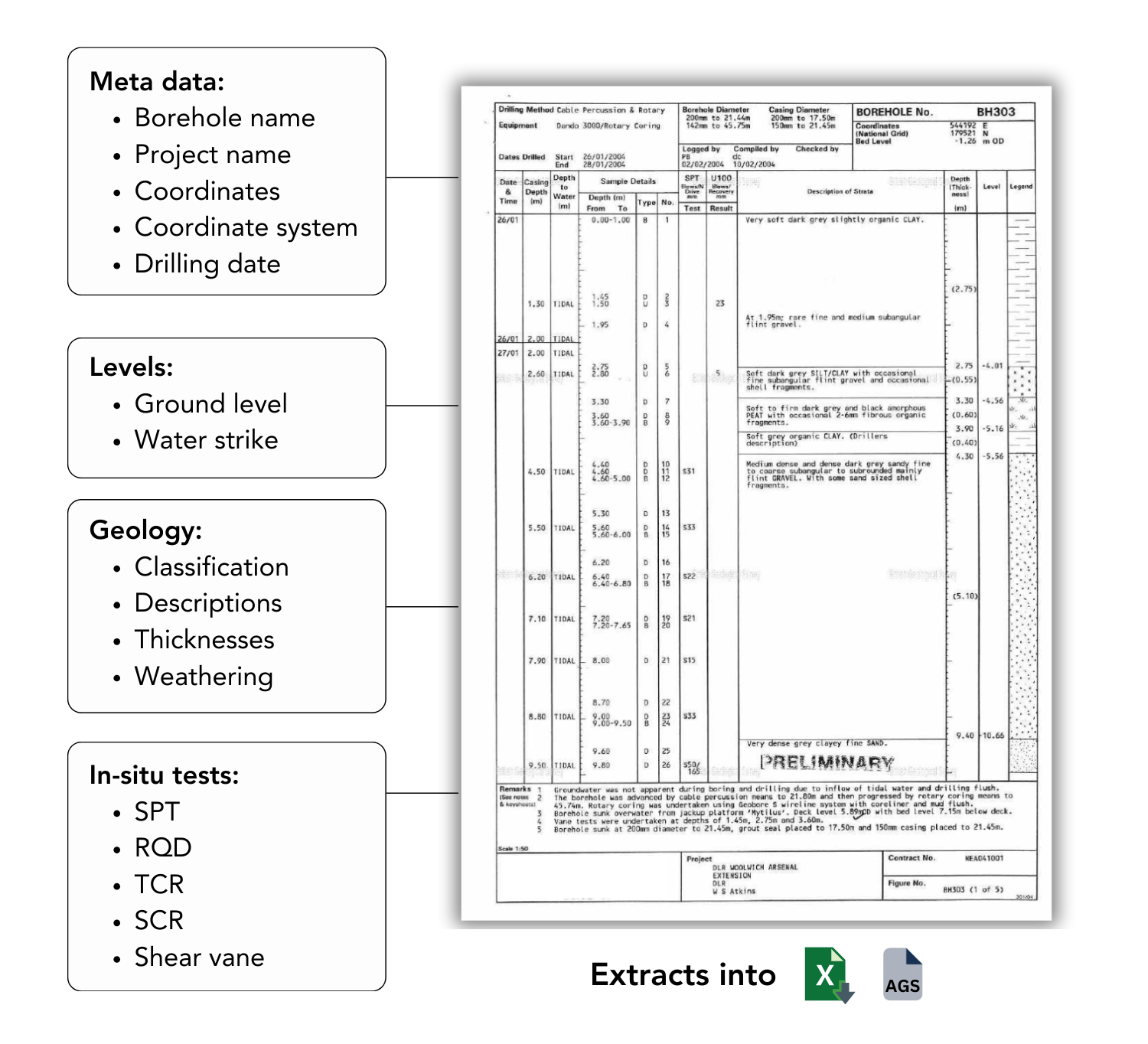
Extract data from borehole logs.
Upload PDF geotechnical reports — scanned or digital. Civils.ai reads every borehole log and converts it into structured AGS 4.1 and Excel data, geo-referenced and ready for OpenGround or Leapfrog.
- Works with scanned and handwritten logs. There is no need to split reports into individual pages, upload the entire document.
- Extracts 16+ data groups (geology, in-situ tests, lab data)
- AGS 4.1 output ready for downstream tools
- Geo-referenced — plot directly on your site map
Understand subsurface conditions on your site.
Civils.ai turns a stack of geotechnical PDFs into structured data, ground models and foundation insight — so estimating decisions stop relying on a single engineer's memory.
From PDF to structured ground data in three steps.
Drop your geotechnical reports and drawings, run the workflow, get back AGS 4.1, Excel and a marked-up PDF — every result QA-reviewed by our engineers before delivery.
Upload PDFs & run
Drag & drop drawings or geotechnical reports — scanned, handwritten or digital. Civils.ai starts processing the moment they land.

Extract to AGS 4.1 & Excel
Borehole and lab data is structured into AGS and Excel — ready for QA and integration with your existing geotech workflows.

Geo-locate & visualise
Coordinates carry through, so every borehole and quantity plots straight onto your site map and 3D ground model.
Built for the way groundworks teams actually work.
Stop the manual takeoff grind, share repeatable workflows across your team and understand all the details about about the opportunity.
Edit the results
Make any small adjustments needed before exporting as an Excel and annotated PDF.
Share your repository
- Save AI workflows to your team account
- Give teammates permission to run them
- Share outputs and results across the firm
Run checks and searches across bid documents
We go beyond measuring with an intelligence layer allowing you to run questions across the entire set of plans and bid documents to find answers.
Frequently asked questions.
Answers to common questions about our services. Can't find what you're looking for? Get in touch.
Start using Civils.ai today.
Join 200+ contractors and consultants cutting takeoff time by up to 90%. No setup fees, cancel anytime.
Get started