 Mary Janine L. Kamenić
 Julianna Widlund P.E
 Stevan Lukic CEng

Photo by Kaustubh Raj on Unsplash
Earthwork takeoff software turns a grading plan into cut, fill and haul quantities. Here's how the grid, cross-section and surface methods work, where swell and shrink go wrong, how to read a mass haul diagram, and what the main tools do.
Quick Summary
| Topic | Key Finding |
|---|---|
| What earthwork takeoff software does | Builds existing and proposed surfaces from drawings, then reports cut, fill, strip and haul quantities |
| Three measuring methods | Grid (cell area × depth), cross-section (average end area) and surface (TIN) comparison |
| Standard corridor method | Average end area, V = (A1 + A2) ÷ 2 × L, used in DOT design manuals such as FDOT and WYDOT |
| Most common unit error | Mixing bank, loose and compacted yards: haul is priced loose, fill is placed compacted |
| Haul | A mass haul diagram shows where cut balances fill and how far material must travel |
| Where AI helps | Measuring areas and lengths from PDF site plans and reading boring logs, with an estimator reviewing the output |
Earthwork takeoff software measures how much dirt a site needs to lose or gain. It compares the existing ground with the proposed grade, then reports cut, fill, topsoil strip and the haul between them. For sitework subcontractors, a surface built wrong in the takeoff is wrong in every yard after it. This guide covers how the methods work, the steps from drawings to quantities, and what to look for in excavation estimating software.
Key Term Definitions
Cut: Material excavated where the existing ground is higher than the proposed level.
Fill: Material placed where the existing ground is lower than the proposed level (embankment, in highway terms).
Bank, loose and compacted yards (BCY, LCY, CCY): Soil volume in place, after digging, and after compaction. Swell and shrink factors convert between them.
TIN surface: A triangulated irregular network, a 3D surface built from points, contours and breaklines.
Mass haul diagram: A curve of cumulative cut minus adjusted fill along an alignment, used to find balance points and haul distance.
Why Earthwork Takeoffs Go Wrong
Most earthwork misses come from the surfaces and the units, not the arithmetic.
The Florida DOT design manual is blunt about it: "The primary causes for inaccurate earthwork quantities are found to be errors in calculating end areas and choosing inappropriate intervals between the cross sections" (FDOT Design Manual, Section 216 Earthwork). On site jobs, it shows up as a mis-traced contour, a wrong datum or a sheet read at the wrong scale.
The other common misses are in what the surface represents:
- Finished grade used as subgrade — the grading plan shows top of pavement or top of slab, but you excavate to the bottom of the section. Pavement, base and slab thickness must come off the proposed surface.
- Topsoil left in the balance — stripped topsoil can't go back as structural fill, so it needs its own quantity and its own stockpile.
- Unsuitable material and rock ignored — the geotechnical report and boring logs decide how much of the cut is usable, and how much is rock.
- Groundwater ignored — a high water table can change both the method and the cost of excavation. See our guide to geotechnical dewatering techniques.
- Bank yards priced as truck yards — the takeoff is in bank measure, the trucking is loose, and the fill is compacted.
These are failures of process, not failures of effort.
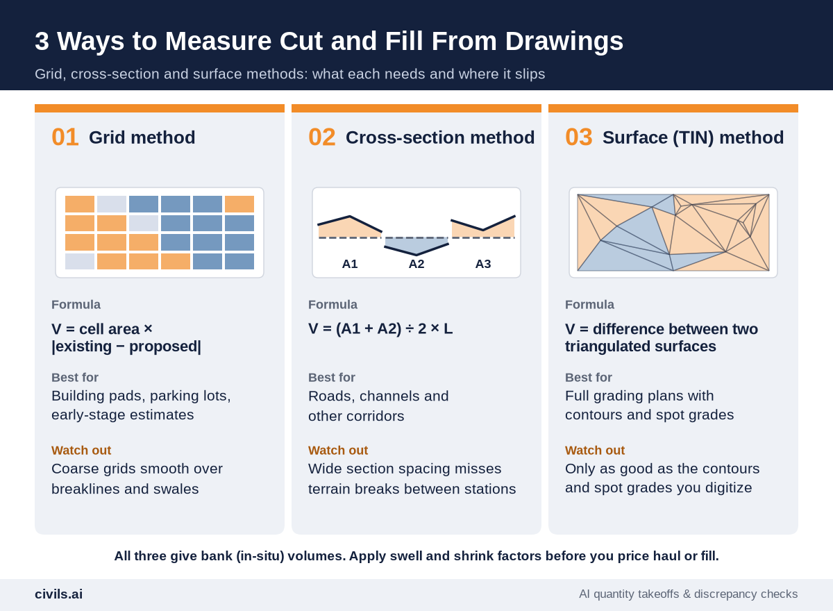
3 Ways Earthwork Takeoff Software Measures Cut and Fill
1. Grid Method
Lay a regular grid over the site. At each cell, take the existing and proposed elevation, multiply the depth difference by the cell area, and add up cut and fill separately. It's quick and easy to check, which suits pads, parking lots and early estimates. The catch is resolution: a coarse grid smooths over swales and ridges between grid points.
2. Cross-Section (Average End Area) Method
Cut cross-sections at regular stations along an alignment, measure the cut and fill area at each, and average adjacent pairs: V = (A1 + A2) ÷ 2 × L. It is the standard method in highway design. The Wyoming DOT Road Design Manual notes that cross-sections on rural projects are generally taken at 100 ft on tangents and 50 ft on curves, and that the method is "exact only if A1 = A2" (WYDOT Road Design Manual, Earthwork). It suits roads and channels more than irregular building sites.
3. Surface (TIN) Method
Build a triangulated surface for existing ground and another for the proposed design, then calculate the volume between them. Most modern earthwork estimating software works this way, and it handles irregular sites best, but it's only as good as the contours and breaklines you trace. Grid-based and triangle-based results for the same surfaces won't always match. Trimble's own help notes that its earthwork volumes can use either method, so "direct comparison to other takeoff products may not yield an equivalent answer" (Trimble Business Center help).
How to Measure Cut, Fill and Haul From Drawings: 7 Steps
Step 1: Collect the Right Documents
You need the existing topographic survey, the grading plan, typical pavement and slab sections, utility plans, the geotechnical report and any earthwork specs. GCs issuing the sitework package should list every sheet by revision, as in our request for bid template.
Step 2: Set the Scale and Datum
Calibrate each PDF sheet to a known dimension, not the title-block scale alone. Confirm that the survey and the design use the same vertical datum.
Step 3: Build the Existing Surface
Trace existing contours and spot elevations, and add breaklines at ridges, ditches and pavement edges. Check it in 3D before moving on.
Step 4: Build the Proposed Surface and Adjust to Subgrade
Trace proposed contours, spot grades and pad elevations. Then lower each area by its section depth: pavement and base under parking, slab and capillary layer under buildings, topsoil depth under landscaping.
Step 5: Take Off Topsoil Strip
Calculate strip as area × strip depth over the disturbed limits, and track it separately from mass cut. The advanced cut and fill calculator keeps topsoil strip out of the cut/fill balance for exactly this reason.
Step 6: Calculate Bank Cut and Fill
Run the volume report by area, phase or stratum. Split rock from soil where the boring logs show it, and flag unsuitable material.
Step 7: Apply Swell and Shrink, Then Plan the Haul
Convert cut to loose yards for trucking and fill to compacted yards, then decide where surplus goes and where borrow comes from.
Swell and Shrink: Bank, Loose and Compacted Yards
A site balanced in bank yards rarely stays balanced once the dirt is dug and compacted. Site-specific geotechnical data should always win. For early estimates, Civils.ai's soil bulking and swell factor calculator uses these typical published ranges, citing references such as the Caterpillar Performance Handbook:
| Material | Bulking (loose ÷ bank) | Shrink (compacted ÷ bank) |
|---|---|---|
| Clay | 1.20–1.30 | 0.80–0.90 |
| Sandy clay / common earth | 1.15–1.25 | 0.85–0.95 |
| Sand | 1.05–1.15 | 0.90–1.00 |
| Gravel | 1.10–1.20 | 0.90–1.00 |
| Rock (blasted) | 1.40–1.50 | 0.95–1.05 |
A worked example shows why it matters. Take 10,000 BCY of clay cut at a 1.25 bulking factor: that's 12,500 LCY to haul. If the same clay is compacted as fill at a 0.85 shrink factor, it makes 8,500 CCY. A site that "balances" at 10,000 yards of cut and 10,000 yards of fill is 1,500 compacted yards short. To size the trucks, use the truck load and haulage calculator.
Mass Haul Diagrams: Where the Dirt Goes
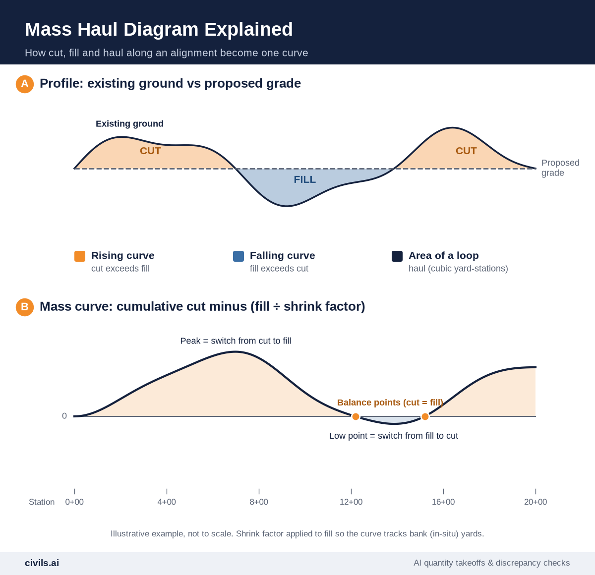
Quantities tell you how much dirt moves. A mass haul diagram tells you how far. WYDOT describes it with a truck analogy: drive along the alignment, add excavation to the truck and remove embankment, adjusted by the compaction factor. The load at any station is the mass ordinate (WYDOT).
- Rising curve — cut exceeds fill over that stretch.
- Peaks and low points — where the work switches from cut to fill, or back.
- Balance points — where the curve crosses zero and cut equals adjusted fill between them.
- Area of a loop — the haul, measured in units such as cubic yard-miles or cubic yard-stations.
Two jobs with the same yardage can need very different fleets if one moves dirt 300 ft and the other a mile.
Earthwork Takeoff Software Compared
The tools below are dedicated cut and fill software. Features are taken from each vendor's own site. Check current pricing and versions with the vendor.
| Tool | What the vendor says it does |
|---|---|
| AGTEK | Earthwork takeoff from PDF, CAD or manual data (Gradework), Highway 4D for corridor mass haul and phasing, and Underground for utility trenching |
| InSite Elevation Pro | Earthwork and utility takeoff from PDF, CAD and drone data, cut and fill contour maps, and GPS machine control model export. It replaces InSite SiteWork, whose technical support ended on 12/31/23 |
| Carlson Takeoff | Cut/fill, subgrade, strata, topsoil and over-excavation volumes from 3D triangulation models. Runs on AutoCAD or IntelliCAD, digitizes PDFs and supports shrink/swell factors |
| Trimble Business Center | Site and corridor takeoff reports, swell and shrink adjustments, and mass haul diagrams for sites and corridors |
| Kubla Cubed | Earthworks estimating from on-screen PDF take-off or CAD and LandXML files, with a TIN prism volume engine |
| Civils.ai | AI takeoff of paving, landscaping, drainage and utility quantities from PDF drawings, plus borehole log extraction to AGS 4.1 and Excel. Every output is reviewed by an engineer. AI cut and fill volumes are listed as coming soon |
The dedicated tools lead on volumes and machine control models. They still lean on the estimator for tracing contours, spot grades and breaklines. For a wider look at takeoff tools, see our roundup of the best AI takeoff software.
How AI Changes Earthwork Takeoff
An earthworks bid isn't just yards. It also covers curb, paving, storm and sanitary runs, structures, fencing and landscaping. Measuring those from PDF site plans is slow, repetitive work.
Generic AI tools (such as ChatGPT and Microsoft Copilot) aren't built to measure a scaled PDF or show which line they measured. Purpose-built construction AI tools are. Civils.ai measures earthworks, utilities and landscaping quantities from your PDF drawings. You upload the drawings and describe the scope, and you get areas, lengths and counts back as Excel and an annotated PDF. That includes drainage runs by pipe diameter, duct and conduit lengths, manholes and paving areas. Civils.ai reports over 97% accuracy on takeoffs from modern PDFs, and every output goes through human review by its engineering team before delivery.
Below grade, Civils.ai reads boring logs from geotechnical reports, scanned or digital, into AGS 4.1 and Excel data, which helps split rock from soil. Civils.ai says it has digitized over 100,000 boreholes since 2022 (see AI borehole log extraction).
For cut and fill volumes, Civils.ai lists AI takeoff as coming soon. In the meantime, the cut and fill calculator gives a quick bank-measure balance by zone or survey grid for early appraisal. Try AI earthworks takeoff on your site plans, or see the plans on the pricing page.
AI-prepared takeoffs are a draft to support your work and should be reviewed by a qualified professional before you bid. The surface checks, the subgrade adjustments and the haul plan stay with the estimator.
Earthwork Takeoff Checklist
- Documents current — survey, grading plan, sections, utilities and geotech report, all at the latest revision
- Scale and datum verified — every sheet calibrated, and survey and design on the same vertical datum
- Existing surface checked — breaklines added, no spikes or flat spots in the 3D view
- Subgrade adjusted — pavement, base, slab and topsoil depths taken off the finished grade
- Topsoil separate — strip and respread quantities tracked outside the mass balance
- Rock and unsuitable flagged — taken from boring logs, not assumed
- Units consistent — bank for excavation, loose for haul, compacted for fill
- Haul planned — import, export, stockpile locations and distances priced
The Bottom Line
Earthwork takeoff software does the math. The estimator still owns the surfaces. Get the datum, the subgrade adjustments and the units right, and grid, section or TIN will all get you close. Get them wrong, and the best software just gets you to the wrong number faster. Speed without a system produces faster mistakes.
Frequently Asked Questions
What is earthwork takeoff software?
It's software that builds existing and proposed ground surfaces from drawings, survey or drone data and calculates cut, fill, topsoil strip and related quantities.
Which cut and fill method is most accurate?
For irregular sites, comparing two TIN surfaces is generally the most detailed, provided the contours and breaklines are traced correctly. For roads and corridors, average end area at close station intervals is the standard method in DOT manuals.
Can you do an earthwork takeoff from PDF drawings?
Yes. Most earthwork estimating software lets you calibrate a PDF and trace contours and spot grades on screen. Always verify the scale on every sheet.
What is the difference between bank, loose and compacted yards?
Bank yards are soil in place, loose yards are soil after digging, and compacted yards are soil after placement. Price excavation in bank yards, trucking in loose yards and fill placement in compacted yards.
Can AI do earthwork takeoffs?
Partly, today. Tools such as Civils.ai measure paving, drainage, utility and landscaping quantities from PDF site plans and extract boring log data, with human review. Civils.ai lists AI cut and fill volumes as coming soon. An estimator should review every AI-prepared quantity before it goes into a bid.
Related reading: What is a takeoff in construction? and AI for PDF and CAD quantity takeoffs.